
I have a PDA and am looking at running both street navigation as well as gps way points for offroad use.
What software do you use for general day to day navigation and also for gps waypoint mapping.
Is there anything that will do both or do you run 2 seperate programmes.
Thanks.
Notice: We request that you don't just set up a new account at this time if you are a previous user.
If you used to be one of our moderators, please feel free to reach out to Chris via the facebook Outerlimits4x4 group and he will get you set back up with access should he need you.
If you used to be one of our moderators, please feel free to reach out to Chris via the facebook Outerlimits4x4 group and he will get you set back up with access should he need you.
Recovery:If you cannot access your old email address and don't remember your password, please click here to log a change of email address so you can do a password reset.
gps / mapping
Moderators: toaddog, TWISTY, V8Patrol, Moderators
Re: gps / mapping
I run Tomtom for street navi and OziCE for when offroad.tropey wrote:I have a PDA and am looking at running both street navigation as well as gps way points for offroad use.
What software do you use for general day to day navigation and also for gps waypoint mapping.
Is there anything that will do both or do you run 2 seperate programmes.
Thanks.
Normally just use the 25k topo maps (NSW) in OziCE.
Ed

Oziexplorer seems very popular for offroad tracks and waypoints etc. U've got many options for street nav such as Destinator, Co-Pilot, Tom-Tom, Navman etc. but AFAIK none of these have very many offroad tracks except forestry roads etc and arent very detailed which is why i think most a program for each use.
01 GU Patrol 4.2TD Wagon


I beg to differ...Emo wrote:I've got an Ipaq HX4700 and it's got the best screen available.Mrs Ludacris wrote:What are some Highly Recommended GPS Units?
http://www.pointnshoot.org/modules.php? ... =0&thold=0
but screen quality is definitely a big issue for the PDA, as for GPS to feed it... Sirf chips seem to be highly recomended.
Spock
www.pointnshoot.org
Suzuki Auto Spares Springwood
Century Batteries
Sylverkey
Extreme Coatings
Control Synergy
Suzuki Auto Spares Springwood
Century Batteries
Sylverkey
Extreme Coatings
Control Synergy
It really depends on how much you want to set it up. With Oziexplorer you can scan your own maps so the detail is as good as any paper topo map you use. Saving it as a ECW also compresses it nicley for your pda running the CE version. Would be better if you could use JPG2000 but things are slowly going this way. I use a navman sleeve on my PDA with OziexplorerCE. If I had money spare a better choice is running a toughbook witn a Magellan hooked into it. It is simlar computing power as a laptop, half the size so would fit nice in your 4b and much more robust.Emo wrote:Oziexplorer is restricted by the quality and detailof the maps you run on it.
FJ62 Crusier GM V8 Diesel Lockers 33 MTs/35 117 extremes
Macarthur District 4WD Club http://www.macarthur4wdclub.com.au
Macarthur District 4WD Club http://www.macarthur4wdclub.com.au

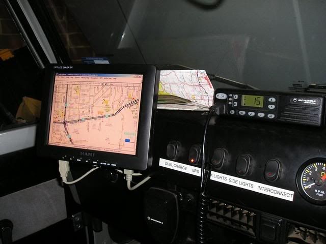

That's not very portable though. I just clip mine out of the cradle and off I go. I've got 8 hours of battery life.Pinball wrote:I beg to differ...Emo wrote:I've got an Ipaq HX4700 and it's got the best screen available.Mrs Ludacris wrote:What are some Highly Recommended GPS Units?
http://www.pointnshoot.org/modules.php? ... =0&thold=0
but screen quality is definitely a big issue for the PDA, as for GPS to feed it... Sirf chips seem to be highly recomended.
Spock

Who is online
Users browsing this forum: No registered users and 2 guests